

Using Flood Platform for Modelling in the Milwaukee Estuary
- Mar 11
- 2 min read
“ Flood Platform enabled fast, iterative simulations that supported ongoing geometry updates, flow revisions, and design scenario evaluations throughout the Milwaukee AOC project.”
Kumar Aman, Hydraulic Modeller, Jacobs
Key Facts
Supported EPA-led restoration of three major Milwaukee river systems by delivering a robust, design‑ready hydraulic model.
Leveraged cloud computing to overcome 10+ hour local runtimes, enabling rapid iteration during an evolving design process.
Integrated fine‑scale mesh, dozens of hydraulic structures, and lake‑level variability to reflect real‑world system complexity.
Provided actionable insights for sediment cap design, habitat restoration elevations, and floodplain comparison against FEMA benchmarks.
Project Background
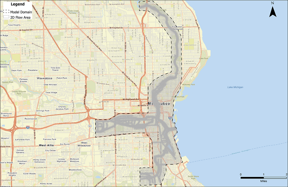
Jacobs was engaged by the U.S. Environmental Protection Agency (EPA) to support the remedial and restoration design for the Milwaukee Estuary Area of Concern (AOC) in Milwaukee, Wisconsin. This AOC includes portions of the Milwaukee, Menomonee, and Kinnickinnic Rivers. Historical discharges from point and non-point sources within and upstream of the AOC have resulted in sediment contamination and floodplain degradation.
To inform design decisions, Jacobs developed a detailed 2D flood model using HEC-RAS and deployed it on Flood Platform, a cloud-based modelling tool.
Project Objectives
The model was developed to:
Estimate water surface elevations and flow velocities to support sediment cap design.
Determine bankfull elevations for habitat and shoreline restoration.
Evaluate the impact of lake-level fluctuations (seiching) on flood behaviour.
Compare modelled flood extents with FEMA’s 100-year floodplain maps.
Model Highlights
Coverage: Over 9 square miles of river and floodplain.
Resolution: Fine computational mesh with approximately 95,000 cells.
Structures: Incorporated 45 bridges and other hydraulic structures from FEMA 1D models.
Complexity: Large domain and fine resolution resulted in run times exceeding 10 hours per simulation on local machines.
Flood Platform Capabilities Utilised
Throughout the project, the model underwent multiple geometry revisions, flow input adjustments, and scenario updates in response to client and design team feedback. Each update required several rounds of simulations to validate results. Because of these computational demands, running simulations locally was not practical. Flood Platform addressed this challenge by enabling faster execution and streamlined scenario management.

Kumar Aman
Kumar is a Hydraulic Modeller based in Sacramento with experience in ecosystem restoration, transportation drainage, sediment transport, and flood risk assessment across various U.S. projects.


.jpg)
